Technology Overview
Location has become infrastructure. Delivery routes, autonomous vehicles, utility repairs and climate assessments all depend on knowing exactly where things are and how they change. Mapping and GIS technology supplies that answer. It turns satellite pixels, laser pulses, drone flights and GNSS signals into maps, models and decisions. AI is speeding up the shift, and location data now increasingly feeds intelligent agents and automated workflows.
This ebook tracks the full stack:
- GIS platforms such as ArcGIS anchor enterprise and government mapping.
- LiDAR makers and photogrammetry developers capture the world in 3D.
- Drone software firms turn site flights into measurable models.
- Earth observation companies monitor water leaks, crops and infrastructure from orbit.
- GNSS receiver makers, correction services and alternative positioning specialists push accuracy to centimeters, even where GPS is jammed.
- Location platforms power navigation for carmakers, ride-hailing and logistics.
- Indoor positioning extends maps into hospitals, airports and stores.
National mapping agencies, research institutes and standards bodies complete a sector where precision, interoperability and fresh data drive real value.
Current Products and News
- Mapbox announced "Location Infrastructure for AI" on September 17, 2026. Earlier in the year it revealed that Toyota's next-generation navigation system is built with Mapbox and introduced Mapbox 3D Lanes.
- Trimble Inc. used its 2026 Insight Conference in San Diego on Sept. 28 to unveil transportation offerings, including voice AI, route and trailer orchestration and agent-ready TMS platforms. On Sept. 15 it introduced the ST30 Smart Target with integrated GNSS capabilities.
- PlanetIQ won a two-year NOAA task order on September 24, 2026. The contract is worth a minimum of $28.4 million and up to $47.3 million for daily GNSS-RO profiles and low-latency TEC tracks. Weeks earlier, NOAA selected it for its Space-Based Environmental Monitoring IDIQ.
- Open Geospatial Consortium (OGC) secured a new five-year NGA contract to accelerate federal geospatial standards collaboration and published the LAZ 1.4 Community Standard. Ordnance Survey also renewed and expanded its OGC Strategic Membership.
- HERE.com expanded its European collaboration with NIO on 23 September 2026 to support fresher maps and Navigation on Autopilot. Earlier that month it introduced AI-powered route intelligence for fleets at IAA Transportation 2026.
- TomTom International BV. brought its location intelligence to Microsoft Fabric on September 30, 2026. The move follows new traffic and mapping deals with citiEU, Cofiroute and Cedar Electronics.
- SimActive Inc. has released three Correlator3D upgrades in 2026:
- Version 11 with Gaussian Splatting in April
- Version 11.1 with revamped aerial triangulation in July
- Faster script processing in September
- DroneDeploy made Ground Pro available on September 22, 2026, turning devices field teams already carry into measurable 3D site documentation. A day later it added Insta360 X6 support across all Ground capture modes.
10 Leading Companies
- Garmin International, Inc.: Garmin's GPS and mapping technology spans automotive, fitness, outdoor, aviation and marine devices, and its strong brand just earned NMEA Manufacturer of the Year for a record 12th consecutive year.
- Mapillary: Mapillary is a leading provider of crowdsourced street-level imagery used globally by mapping companies, autonomous vehicle developers, planners and government agencies.
- SimActive Inc.: SimActive's Correlator3D photogrammetry software makes it a significant player in geospatial data processing, and a steady run of 2026 releases keeps it moving.
- DroneDeploy: DroneDeploy is a leading drone mapping platform covering the whole workflow from flight planning to 3D models, now extending into ground capture with Ground Pro.
- Mapbox: Mapbox is a prominent location data platform for developers and enterprises, with automotive momentum through Toyota and a new push into location infrastructure for AI.
- RIEGL Laser Measurement Systems GmbH: RIEGL is a key player in airborne, mobile and terrestrial LiDAR, with systems noted for accuracy, range and data density.
- Open Geospatial Consortium (OGC): OGC sets the international interface standards that let geospatial systems share data, and it is backed by a new five-year NGA contract.
- Environmental Systems Research Institute (ESRI): ESRI is the world's leading GIS supplier, and its ArcGIS platform is used by an estimated 300,000 organizations, including all 50 US states.
- Inrix, Inc.: Inrix is a global leader in transportation analytics and connected car services, delivering real-time traffic, map data and navigation that automakers integrate into their vehicles.
- Trimble Inc.: Trimble combines GNSS positioning, geospatial hardware, software and correction services across construction, agriculture and transportation, and it launched new AI-driven and surveying products in September 2026.
Get Ahead in Mapping and GIS
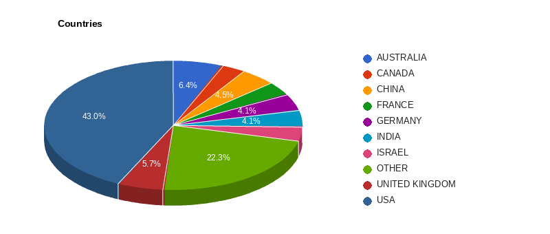
This market moves every day. On October 2, 2026 alone, 56 companies in this ebook updated their newsrooms. Computer Review puts all 314 companies across 37 countries in one place, with 168 job pages tracked, so you see the moves as they happen.
With a subscription you can:
- Catch every press release the day it is published
- Know who leads each company and who is hiring
- Size up markets country by country
- Find any company or topic in seconds with keyword search
Start today for just $15 a month, cancel any time, or get the best value at $120 a year and save 33%.